Geography of volcanoes. Active, dormant and extinct volcanoes
Volcano is one of the most beautiful, unexpected and scary riddles nature. There are more than two hundred of them on Earth, and each one amazes with its height and power. Even volcanoes that are considered extinct cannot be trusted, because one day they may “wake up” and start erupting lava. Which of all active volcanoes is considered the highest? Where are they most? We will talk about this and much more in this article.
The area with the most active volcanoes
A volcano is a crack earth's crust, through which ash, steam, fiery lava, and gases are thrown out. Appearance The volcano resembles a mountain. Why are volcanoes divided into active and extinct?
If the slightest activity of a giant mountain has been recorded in the history of mankind, then the volcano is considered active. It doesn't have to erupt. By activity we mean even if it simply emits steam and ash once every hundred years.

Many active volcanoes are located in the Malay Archipelago, which is geographically adjacent to Asia and Australia. Russia also has a dangerous zone of active volcanoes. It is located in Kamchatka with the capture of the Kuril Islands. According to scientists, at least 60 volcanoes show signs of activity there every year.

The largest volcano in the world
Mauna Loa is the name of the giant, which in size surpassed all other volcanoes in the world. It is located in Hawaii. Translated from the local language, the volcano is called “Long Mountain”.
The giant's activity was first recorded in 1843. Since then, it has erupted 33 times, making it perhaps the most active volcano on the planet. The last eruption occurred in 1984. Then lava covered 30 thousand acres of land. After the eruption, the territory of Hawaii increased by almost 200 hectares.

Above sea level, Mauna Lao has a height of 4,169 m, and if you count the height from the very center, you get almost 9 thousand m. This is even higher than the highest mountain in the world - Everest.
Mauna Lao is not only the largest, but also the most powerful volcano. 75 thousand cubic km - this is its total volume.
Tallest active volcano in the world
In this part, even scientists have divided opinions. As for the height above sea level, there is no doubt, the highest is the Llullaillaco volcano - 6,723 m. It is located in the Andes between Chile and Argentina. Its last eruption was recorded in 1877.

Another part of the scientists gives the laurels of championship to another volcano located in the Andes, but on the territory of Ecuador - Cotopaxi. Its height above sea level is slightly lower than its competitor - 5,897 m. However, its last eruption was in 1942. And it was much more powerful than the eruption of Llullaillaco.

All scientists agree on one thing - Cotopaxi is the most beautiful volcano. It has an elegant crater and incredibly beautiful greenery at the foot. However, such beauty is very deceptive. Over the past 300 years, 10 powerful eruptions have been recorded. All 10 times, the city of Latacunga, which is located near the foot of the giant, was completely destroyed.
The most famous volcanoes in the world
Despite the fact that the previous volcanoes are the largest and most beautiful, few have heard of them. But there are two leaders that are known to everyone since school lessons - Fuji, Vesuvius and Kilimanjaro.
Fuji is located in Asia, on the island of Honshu, not far from the Japanese capital. Since ancient times, local residents have elevated the volcano to a cult. It rises 3,776 m above sea level and has beautiful contours. The last powerful eruption was recorded in 1707.

Vesuvius is an active volcano in southern Italy. By the way, this is one of the three active volcanoes in the country. Although Vesuvius is not as high as other volcanoes (only 1,281 m above sea level), it is considered one of the most dangerous. It was he who completely destroyed Pompeii, as well as Herculaneum and Stabiae. Its last eruption occurred in 1944. Then the cities of San Sebastiano and Massa were completely destroyed by lava.

Kilimanjaro is not only the highest African volcano, but also the highest point on the continent. Scientists believe that the history of Kilimanjaro goes back two million years. The volcano is located 300 m south of the Equator. Despite this, at its foot accumulated a large number of glaciers

The tallest extinct volcano in the world
The tallest extinct volcano is also located on the territory of two countries - Chile and Argentina. The peak of the Ojos del Salado volcano (translated from Spanish as “Salty Eyes”) is located on the Chilean side. The height of the peak is 6,891 m above sea level.
In the entire history of human existence, Ojos del Salado has never erupted. There were several cases where it emitted water vapor and sulfur. The last time such a case was noticed was in 1993.

This fact made many scientists think about whether Ojos del Salado should be included in the ranks of active volcanoes? If this happens, it will become the tallest active volcano in the world.
Volcanoes are fire-breathing mountains, a place where you can look into the bowels of the Earth. Among them there are active and extinct ones. If active volcanoes show activity from time to time, then information about extinct eruptions has not been preserved in the memory of mankind. And only the structure and rocks that compose them allow us to judge their turbulent past.
Volcanoes occupy an intermediate position. They are characterized by inactivity for many years.
Dormant volcanoes
The division of volcanoes into dormant and active is very arbitrary. People may simply not be aware of their activity in the not-so-distant past.

For example, the famous volcanoes of Africa are dormant: Kilimanjaro, Ngorongoro, Rungwe, Menengai and others. There have been no eruptions for a long time, but light streams of gas rise above some. But knowing that they are located in the zone of the Great East African graben system, we can assume that at any moment they can wake up in all their power and danger.
Dangerous Calm
Dormant volcanoes can be very dangerous. The saying about still life and the devils in it. The history of mankind remembers many cases when a volcano, long considered dormant or even extinct, woke up and brought a lot of trouble to people living in its vicinity.
Most famous example- the famous eruption of Vesuvius, which destroyed, in addition to Pompeii, several more cities and many villages. The life of Pliny the Elder, a famous ancient military leader and natural scientist, was cut short precisely because of him.
The interrupted sleep of volcanoes
The Ruiz volcano in the Colombian Andes has been considered dormant since 1595. But on November 13, 1985, he refuted this by erupting in a series of explosions, each stronger than the other. The snow and ice located in the crater and on the slopes of the volcano began to rapidly melt, forming powerful mud-stone flows. They poured into the valley of the La Gunilla River and reached the city of Armero, located 40 km from the volcano. A stream of mud and stones fell on the city and surrounding villages in a raging mess 5-6 m thick. About 20 thousand people died, Armero became huge. Only those residents who climbed the nearest hills at the beginning of the eruption were able to escape.
The release of gas from the crater of the Nyos volcano caused the death of more than 1,700 people and a large number of livestock. But it was considered extinct long ago. A lake even formed in its crater.
Volcanoes of Kamchatka
The Kamchatka Peninsula is home to a large number of active and dormant volcanoes. It would be wrong to consider them extinct, because here is the collision boundary, which means that any activity in tectonic movements can awaken the dormant formidable forces of nature.

The Bezymyanny volcano, located south of Klyuchevskaya Sopka, was considered extinct for a long time. However, in September 1955, he woke up from sleep, an eruption began, clouds of gas and ash rose to a height of 6-8 km. However, this was just the beginning. The prolonged eruption reached its maximum on March 30, 1956, when a powerful explosion sounded, demolishing the top of the volcano, forming a deep crater with a diameter of up to 2 km. The explosion destroyed all the trees at a distance of up to 25-30 km in the area. And a giant cloud, consisting of hot gases and ash, rose to a height of 40 km! Small particles fell at great distances from the volcano itself. And even at a distance of 15 km from Bezymyanny, the thickness of the ash layer was half a meter.
As with the eruption of the Ruiz volcano, a stream of mud, water and stones was formed, which rolled up to almost 100 km.
Those who have fallen asleep are very dangerous, because they look like the notorious Vesuvius, Mont Pele (Martinique), Katmai (Alaska). They sometimes cause explosions, which would be a real disaster in more densely populated areas.

An example is the eruption of Shiveluch in 1964. The power of the explosion can be judged by the size of the crater. Its depth was 800 m and its diameter was 3 km. Volcanic bombs weighing up to 3 tons scattered over a distance of up to 12 km!
Such powerful eruptions have happened more than once in the history of Shiveluch. Near the small village of Klyuchi, archaeologists managed to unearth a settlement covered with ashes and stones several centuries ago, even before the Russians arrived in Kamchatka.
Threat to humanity
Some scientists believe that it is dormant volcanoes that can cause a global catastrophe that will destroy humanity. At the same time, they talk about long-extinct giants, such as Yellowstone in the Supervolcano, which after its last eruption left a caldera 55 km by 72 km, is located in the “hot spot” of the planet, where magma is close to the earth’s surface.
And there are quite a lot of such giants, sleeping or close to awakening, on Earth.
Dormant volcanoes (list)
Dormant volcanoes | ||
| 1281 m | ||
North America | 752 m | |
Yellowstone | North America | 1610-3462 m (different parts of the caldera) |
O. Iceland | ||
Uturunku | South America | 6008 m |
O. Sumatra | 2157 m | |
New Zealand | 760 m | |
Canary Islands | 3718 m | |
O. Sumatra | 2850 m | |
South America | 5636 m |
In the first decades of the 19th century. extinct volcanoes interested many geologists more than modern fire-breathing mountains; Auvergne, Eifel and Northern Ireland were the subject of heated debate more often than Vesuvius or Etna. First of all, a dispute arose about basalts. A. Werner (1750-1817), a world-famous scientist, the first professor of geology at the Freiberg Mining Academy in Saxony, came up with an erroneous concept about the sedimentary, that is, water, origin of basalts. The ideas of the “Neptunists” were also shared by Goethe. However, already the students of A. Werner - A. Humboldt and L. von Buch correctly understood the volcanic nature of basalts, which contributed to the victory of the “plutonists”.
A. VOLCANIC CHAIN OF PUY (AUVERGNE)
Probably nowhere in Europe are extinct volcanoes better preserved than in Auvergne, in the vicinity of Clermont-Ferrand, central France (Fig. 27.1). In some places they form a chain - hence the name “Puy chain” (Puy means a hill clearly defined in the relief). Already from the window of a train traveling from Paris to Clermont-Ferrand, one can observe both the chain-like arrangement of volcanoes and the sharp boundary between the mountains and the plain (that is, between the Massif Central and the Limagne graben), passing along the fault ledge. The widely known mineral springs of France - Vichy are confined to the eastern side of the graben. Almost all volcanoes are located on a plateau, composed in some places of very ancient (Precambrian) gneisses, in others of relatively ancient (Carboniferous) granites (Fig. 27.2).

Puy de Dome, rising 1465 m behind Clermont-Ferrand, is the highest of the young volcanoes (Fig. 27.3). It is easy to climb it by car, and the trip is worth it, since from the wide peak you can clearly see the distant surroundings. Now this peak is used for television purposes, and once upon a time there stood a Roman temple of Mercury, built from domite (domite is a rock named after the Puy de Dome volcano)! However, for the construction of this temple they did not use local domite (it is too fragile), but domite, which was delivered with great difficulty from Mount Sarkui and from other places. The French geologist F. Glangeau, in one of his works on the “Puy chain” (1913), recalls that it was here that one of the first aircraft built landed. In 1908, the Michel brothers (famous rubber tire manufacturers from Clermont-Ferrand) established a prize of 100 thousand francs for anyone who could fly from Paris to the top of the Puy de Dome in 6 hours. Eugene Renaud succeeded on March 7, 1911. The possibility of landing is geologically justified: the Puy de Dome is an extrusive (consisting of viscous lava squeezed out of the crater - trachyte) very flat dome.

The famous French philosopher, mathematician and physicist B. Pascal, born in Clermont-Ferrand in 1623, carried out his famous experiment on weighing air in 1648 on Mount Puy de Dome. At that time it was already known that the air pressure was equal to the pressure of a column of mercury 76 cm high, which Torricelli explained by the “weight” of the air; but his assumption was not accepted. Pascal had the idea to test this on a mountain, where the weight of air should be less. His relative Perrier successfully carried out this significant experiment: the barometer needle on the Puy de Dome volcano showed that the pressure here was 8 cm lower than in Clermont-Ferrand.
The first geologist to conduct research in this area was Jean Guettard (born 1715), the son of an apothecary, keeper of the collections of the Duke of Orleans, later a member of the Paris Academy (died 1786 in Paris). He compiled a mineralogical map of France and England; he is the author of the first major study on mountain erosion. In 1751, during a trip to Auvergne, he discovered that the material used in the construction of houses and for paving roads (Volvic stone) was volcanic lava. This “trace” led him to the discovery of the extinct volcanoes of the Auvergne. Guettard examined 16 volcanoes, however, having encountered basalts with columnar separation on Mont Dore, he attributed them to sedimentary origin. His work on Auvergne was published in 1756.
It was in Auvergne that the dispute between the Neptunists and the Plutonists began. Guettard supported the former in relation to basalts (but not in relation to cinder cones!), and Desmarais (1765) supported the latter.
Among the first explorers of the Auvergne, one should mention Giraud-Soulavi, an original self-taught proponent of the ideas of the Plutonists, who even tried (in the 18th century!) to establish the sequence of volcanic events. Abbot of Nimes, then vicar of Chalons, an ardent revolutionary and Jacobin, he died in 1813 in Geneva. In his seven-volume work “Natural History southern France“he tried to “link” the data of his geological research with the Bible and teaching catholic church. Let's not judge whether he succeeded.
Sulavi developed the idea that a person's character depends on the soil and geographical location terrain. The air of volcanic regions is supposedly constantly saturated with “electric matter,” so that a person’s nerves are constantly excited and tense; on the contrary, in areas composed of limestone, shales, granites and pebbles, due to a lack of electricity, the physical and spiritual strength of a person is weakened.
Considering this early period of research in Auvergne, mention should also be made of Humphry Davy, a major English chemist, whose name is associated with the invention of the safe miner's lamp (Davy lamp). In 1812, with a letter of recommendation from Napoleon in his pocket, he arrived in Pariou to prove the validity of his theory, according to which volcanic eruptions occur due to the action of water on alkali metals.
The centers of volcanic eruptions of the Auvergne are in some places perfectly preserved. Among them, two sharply different groups can be distinguished. The first, smaller one includes light trachyte domes without cinder and tuff cones and without craters (for example, Puy de Dome). Very viscous lava rises through the volcano's crater in the form of a plug; French geologists cite Peel Peak on the island of Martinique as an example of such a “traffic jam.” There are no lava flows at this group of volcanoes (Fig. 27.4).

Some trachytes are called domites - this is what L. von Buch called the biotite and plagioclase trachytes of the Puy de Dome volcano in 1809. However, they are also observed on other “puys”, for example on Mount Sarqui.
The second, more numerous group is formed by crater volcanoes, small cones composed almost exclusively of andesitic and dark basaltic layered loose strata (Fig. 27.5). But here, too, the first lavas that erupted were often trachytes.

These volcanic centers are characterized by lava flows, the original chaotic landscape of which is still visible in some places today, despite the vegetation covering them. The local name for the streams is "cheires". They flowed into the Liman graben and into the valleys (which, therefore, already existed then), often completely filling them, which caused the rivers to be dammed. Lava flows reached a length of 10-20 km; where they overlapped one another, their total thickness reaches 100 m (Fig. 27.6).

Lavas have long been used as construction material. Above we have already talked about the well-known and valuable “Volvic stone”, which belongs to the group of trachytes containing andesine. Ground water, filtered through lava, becomes so pure that it is exported in cans to other parts of the country.
The most beautiful crater volcano, in my opinion, is the andesitic Puy de Pariu with a height of 1210 m (Fig. 27.5). In terms of its structure (two shafts nested one inside the other), it resembles, of course, the incomparably larger Vesuvius. In its picturesque crater on August 30, 1833, on the initiative of Lecoq, the founding of the French Geological Society was celebrated: “The ceiling of the meeting room was blue sky, lamp - the sun; the carpets were green grass and flowers, hiding the source of the former eruption. Craters and geologists have never been so friendly."
Eruptions undoubtedly occurred during the Quaternary period, even during the last glaciation and later. The youngest lava covers are buried under the pebbles of the terraces, in which reindeer bones were found - therefore, their age is not older than Würm. According to absolute age determinations using the radiocarbon method, the eruption of Pariou occurred 7700 years ago, and the eruption of Puy de la Vache - 8800 years ago.
The Quaternary age of the eruptions is also confirmed by the excellent preservation of the volcanic cones, apparently younger than the Eifel cones.
b) EIFEL MAARS
Maars are small round, often relatively deep, bowl-shaped depressions that pleasantly break the monotony of the landscape of the Rhine Slate Mountains. Geologically, they are so unique that the Rhine name “maars” for these partially water-filled craters has become international. The word "maars" comes from the Latin mare (sea). The teacher of the Trier gymnasium I. Steininger (1794-1878), to whom we owe detailed information about the “extinct volcanoes of the Eifel and the Lower Rhine,” was the first to use this Eifelian name to designate this kind of volcanic forms.
However, the first geological observations in the “volcanic Eifel” were carried out much earlier, under the sign of a dispute (as in Auvergne) between plutonists and neptunists. K. Nose (the mineral nosean is named after him) in his book “Orographic Notes on Siebengebirge and the Adjacent Partially Volcanic Regions of the Lower Rhine” (1790) considered the Rhineland as at least partially “volcanic”. However, he did not consider the maar-like Laah Lake (now no longer classified as a maar proper) to be volcanic.
In 1790, these places were visited by G. Forster, a companion of J. Cook in his second circumnavigation, and later an active participant in the French Revolution. He considered the comparison of the Rhineland with Hekla and Etna to be “an amusing fantasy.” Volcanological research in the Eifel was carried out by the mining director from Bonn E. Dechen (1800-1889), later the director of the Geological Office of North Rhine-Westphalia, W. Arena and the Bonn petrographer I. Frechen. A summary work on maars was recently completed by G. Noll.

Particularly picturesque maars are located in the western Eifel (Fig. 27.7): the deepest Maar Pulfer (74 m; Fig. 27.8-27.9), the Maars Weinfeld, Schalkenmeren and Gemünde lying close to each other, as well as the largest Maar Meerfeld with a diameter of 1480 m. Some information about these maars is given in the table.


Some of these maars silted up and became swamps (Fig. 27.10). The view is especially picturesque from an airplane. In 20 minutes you will examine at least a dozen maars and see that they are crater-like sinkholes; however, unlike ordinary craters, they never crowned a high volcanic mountain and represent a depression in non-volcanic rocks (for example, in the Eifel - in ancient Devonian shales, greywackes, etc.). These are “negative volcanic forms” as opposed to “positive” forms such as Vesuvius, in other words, these are small but completely independent volcanoes, consisting only of a crater. True, the formation of some maars, for example the Meerfeld Maar, involved subsidence processes (and not just volcanic eruptions, as in the craters themselves).

Lava flows never erupted from the Eifelian maars, but they erupted fine-grained basaltic tuffs, often mixed with fragments of non-volcanic Devonian rocks; one of the Dreiser-Weier maars (now dried) ejected large green olivine nodules, of interest to mineralogists. True, the volume of eruption products is significantly smaller than the volume of crater craters (for example, in the Meerfeld Maar). Since the time of Steininger, the formation of maars has been explained primarily by the explosive release of volcanic gases. “These are like craters from a mine explosion,” wrote A. Humboldt in his “Cosmos.” Indeed, the ratio of diameter to depth is the same for maars and craters formed during artificial explosions (as for similar forms on the Moon). It was believed that explosive volcanic gases first rushed up the cracks, thus creating “volcanic channels” (also called vents, necks and diatremes), which expand at the surface - in the form of explosion craters.
However, it is currently assumed that the formation of maars is associated not with one explosive breakthrough of gases, but with the gradual expulsion of volcanic gases from the depths along weakened zones of the earth’s crust. In this case, the gases mechanically expand the channels through which they escape; Particles torn off by gases, as well as larger fragments of side rocks, are mixed with the escaping gas and trapped lava droplets. “Consequently, volcanic channels do not open with suddenly bursting gases... magmatic gases create their own way upward by mechanical expansion of cracks” (G. Noll, 1967). In the Eifel and other similar volcanoes, processes similar to some methods used in the chemical industry took place - fluidization, or fluidization. The gas and the fine particles of matter swirled by it form a mixture that behaves like a liquid.
Based on his theory, Noll proposed a new definition of maar.
“Maars are independent funnel- or saucer-shaped volcanoes, which are depressions in any rock. They are formed as a result of the eruption of gas or water vapor, usually with the participation of fluidization processes, mainly during one eruption cycle. They are typically surrounded by a blanket of loose rock or a low mound of ejecta and may have a small central cone.”
The Eifel maars do not have central cones. However, they are observed, for example, in South Australian maars. There volcanic activity apparently continued somewhat longer than in the Eifel, where its duration probably did not exceed several weeks or months.
The fact that the maars are partially silted detracts from their landscape value, but at the same time increases their scientific significance: the peat deposits of the maars, containing flower pollen, allow more accurate age determinations to be made using pollen analysis and radiocarbon dating. Thus, G. Strack and I. Frechen managed to establish the age of the eruptions of the maars (see table). Wherein great importance acquire thin layers of volcanic ash in or between peat layers (Fig. 27.11).


Thus, these maars, as well as the Laach Lake volcano (11 thousand years old) with its pumice tuffs scattered all the way to Mecklenburg and Lake Constance, are the youngest volcanoes in Germany. Of course, this method of determining age assumes that peat formation began shortly after the formation of the maars and that the ash layers are associated with that particular volcano and not another. In this regard, doubts have recently been expressed (1968) by P. Jungerius and others, who suggest that the ashes partly originate from the Laach Lake volcano. Then all the above numbers characterize the minimum age of individual maars: there were not necessarily eruptions, but they could have been older, although unlikely by much.
Similar, but much older and more severely eroded volcanic structures in the Swabian Alb in the Urach region were previously called “volcanic embryos”. But maars are by no means the initial, but rather the final stage of volcanic activity. Deep magma was no longer capable of creating large volcanoes.
c) GIANT'S CAUSEWAY (NORTHERN IRELAND)
The most famous locality of columnar basalts is the Giants Causeway. Along the coast for almost 100 m near Antrim in Northern Ireland, thousands or tens of thousands of these pillars form a regular mosaic in places. This is not exactly a “road”, but rather a pavement made of basalt, partially flooded by the sea at high tide. Of 100 pillars, about 70 are hexagonal, and this is no coincidence, since in order to divide a surface into hexagons, less work is required than to divide it into squares or triangles. The thickness of the pillars ranges from 15 cm to half a meter. Most of them stand vertically (Fig. 27.12).

It is now completely clear to us that such a beautiful columnar separation arose when the lava solidified and contracted in volume. However, in Goethe’s time, regular mosaics were compared to crystals formed in aqueous solutions, seeing this as evidence of the aqueous origin of basalts.
In addition, other observations were made in Antrim, which at first seemed to confirm the ideas of the “Neptunists.” Near Portrush, the basalts are overlain by marine shales and marls of Jurassic (Liassic) age with an abundant ammonite fauna. The hot basaltic lava, which penetrated here into the Liassic deposits in the form of veins, turned the shales at the contacts into a dark siliceous rock, which the first researchers also mistook for basalt. Well, since sea shells are found in this “basalt,” how can one doubt its aquatic origin. And only later did they learn to distinguish basalts from basalt-like sedimentary deposits of the Liassic altered by “contact metamorphism”.

Somewhat west of the Giant's Causeway, you can see that black basaltic lavas lie on snow-white chalk layers (Fig. 27.13). These beds with lenses of flint nodules represent marine sediments of Late Cretaceous age, as evidenced by numerous finds of belemnites. The sea surf has created picturesque bays, caves, and arches in these deposits (Fig. 27.14).

The lava flows that now form the Giant's Causeway are undoubtedly younger than the Cretaceous, since they overlie the Cretaceous deposits (Fig. 27.15). The basalts belong to the Tertiary period (probably Miocene), and their age is therefore several tens of millions of years. This is directly confirmed by the findings of fossil flora in clayey layers enclosed between individual lava covers. The clayey layers are red in color - a consequence of the fairly warm subtropical climate in the Tertiary period. A thickness of red rocks several meters thick stands out sharply in the steep coastal cliff for many kilometers. This sequence indicates that the "lower" basalts were weathered into laterite, on which lush vegetation (sequoia, pine, etc.) developed, before, after a long interval, everything was buried under the younger ("middle") basalts. The basalts of the Causeway of Giants are much older than the Puys of the Auvergne and the Maars of the Eifel, which are very young from a geological point of view. It is therefore not surprising that the basalt pillars of Antrim are the last remnant of what is undoubtedly a larger volcanic region; most of It was demolished long ago, and the volcanic centers were preserved only in places. Basalts very reminiscent of Northern Irish basalts are also known in the Faroe Islands, in the east and north-west of Iceland, and in Greenland. It is highly doubtful that these basalts once formed a single giant basaltic plateau, and yet they are united under the general name of the “Thule basalt province.”

Volcanologists sometimes compare volcanoes to living creatures that are born, develop and ultimately die. The age of volcanoes is hundreds of thousands and even millions of years. With such a “life expectancy”, one eruption per century corresponds to a rather vigorous rhythm. Some volcanoes are content with one eruption every millennium or so. It happens that the resting phases last for 4000-5000 years. As a rule, active volcanoes include those that erupted in historical times or showed other signs of activity (emission of gases and steam).
An active volcano is one that periodically erupts currently or at least once in the last 10,000 years.
Volcano ETNA (Sicily) Eruption 1999
This is one of the most active volcanoes on Earth. From 1500 BC e. More than 150 eruptions have been recorded.
The highest volcano in Russia. One of the young volcanoes, its age is 5000-7000 years. One of the most active, it has erupted more than 30 times over the past 300 years.
volcano tectonics crack extinct
Volcano Klyuchevskaya Sopka. Kamchatka.

Mauna Loa Volcano, Hawaiian Islands, Pacific Ocean.

The tallest volcano in the world, its height is more than 10,000 m, if you count from the bottom Pacific Ocean.
The youngest volcano in Hawaii, and the most active in the world. From one crater on its eastern slope, lava has flowed continuously since 1983.
Kilauea Volcano. Hawaiian Islands.


There are about 1,300 active volcanoes on Earth. An active volcano is one that periodically erupts at the present time or within the memory of mankind.
During volcanic eruptions earth's surface A large amount of solids is supplied in the form of frozen lava, pumice, and volcanic ash.
Volcanoes bring deep matter from the depths of the Earth to the surface. During an eruption, large amounts of water vapor and gas are also released. Scientists have now concluded that volcanic water vapor formed significant part water shell Earth, and gases - the atmosphere, which was subsequently enriched with oxygen. Volcanic ash enriches the soil. Eruption products: pumice, obsidian, basalt are used in construction. Mineral deposits such as sulfur form near volcanoes.
A volcano that has never erupted in 10,000 years is called dormant. The volcano can remain in this state for up to 25,000 years.
Volcano Maly Semachik. Kamchatka.

Lakes often form in the craters of dormant volcanoes.
Dormant volcanoes often begin to act. In 1991, the strongest in the twentieth century. The eruption released 8 cubic meters into the atmosphere. km of ash and 20 million tons of sulfur dioxide. A haze formed that enveloped the entire planet. By reducing the illumination of its surface by the Sun, this led to a drop in the average global temperature by 0.50 C.
Volcano Pinatubo. Philippines.

Elbrus volcano. Caucasus. Russia.

The highest volcano in Russia, it erupted more than 1500 years ago.
Extinct volcanoes are volcanoes that have been dormant for many thousands of years. Volcanologists consider a volcano to be extinct if it has not erupted for at least 50,000 years.
Mount Kilimanjaro. Africa.

When volcanic activity finally stops, the volcano is gradually destroyed by weathering - precipitation, temperature fluctuations, wind - and over time is leveled with the ground.
In areas of ancient volcanic activity, severely destroyed and eroded volcanoes are found. Some extinct volcanoes have retained the shape of a regular cone. In our country, the remains of ancient volcanoes can be seen in Crimea, Transbaikalia and other places.
More articles on geography
Nature of the islands of Oceania
My theme course work- Nature of the islands of Oceania. This is a very interesting topic because the nature on the islands and on the mainland is very different due to the isolation of the islands. The island is a...
Ethnic factors of regionalism (diffusion of races, homeland, ethnogenesis, ethical characteristics and contacts) using the example of Belgium
Regional studies is a geographical discipline that deals with the comprehensive study of countries, systematizing and summarizing heterogeneous data about their nature, population, economy, culture and social...
Protecting slopes and ravines from erosion
Erosion is the destruction of soil by jets and streams of melt, rain, storm water or wind. It leads to soil washout and erosion and causes the development of ravines. The system contains anti-erosion...
Active and extinct volcanoes have always attracted people. People settled on volcanic slopes to engage in agriculture, because volcanic soil is very fertile.
Today, the majestic geological formations attract crowds of tourists who want to admire their beauty.
Those thirsty for extreme sports are not stopped even by the most dangerous natural objects - active volcanoes.
In contact with
List of active volcanoes in the world
Today we will look at where there are active volcanoes in the world. Most of them are located along the coast. This zone is called the Pacific Ring of Fire. The second most volcanic activity zone is the Mediterranean belt.

There are about 900 active volcanoes on land
About 60 geological formations on earth explode every year. Let's look at the most dangerous ones that are active, as well as a few impressive ones that are dormant.
Merapi, Indonesia
Merapi is the most impressive, nicknamed "Mountain of Fire". It is located on the island. Java, reaches a height of 2914 m. Large-scale emissions occur every 7 years, and small ones twice a year. Smoke is constantly coming out of its crater. One of the most significant tragedies associated with the activity occurred in 1006. Then a fierce disaster destroyed the Javanese-Indian state of Mataram.

In 1673, another powerful eruption erupted, as a result of which the towns and villages located at the foot were destroyed. In 1930, volcanic eruptions killed 1,300 people.

The last Merapi eruption occurred in 2010, when the evacuation of 350 thousand people was required. Some of them decided to return and died in the lava flow. 353 people were injured then.
In that last disaster, Fire Mountain ejected a mixture of ash and gas at a speed of 100 km/h, with temperatures reaching 1000°C.
Sakurajima, Japan
Sakurajima is located on the island. Kyushu. The mountain once stood separately, but during one of the eruptions it joined the Osumi Peninsula with the help of lava. It rises to a height of 1117 m. It consists of three peaks, the highest of which is the northern one.

The activity of Sakurajima increases every year, and until 1946 there were only 6 emissions. It has been erupting continuously since 1955.
Note: one of major disasters occurred in 1914, when the disaster claimed the lives of 35 people. In 2013, 1097 minor emissions were recorded, and in 2014 - 471.
Aso, Japan
Aso is another volcanic giant of the island. Kyushu. Its height is 1592 m. It is a caldera, in the middle of which there are 17 cones. The most active of them is Nakadake.

IN last time Aso erupted lava in 2011. Since then, about 2,500 tremors have occurred here. In 2016, the ejection process was accompanied by an earthquake.
It is worth noting: Despite the danger associated with the extreme activity of Aso, about 50 thousand people live in the caldera, and the crater itself has become a popular destination for active tourism. In winter, people ski on the slopes of Aso.
Nyiragongo, Republic of Congo
Nyiragongo refers to mountain system Virunga is the most active in Africa. The height is 3470 m. In its crater there is a huge seething lava lake, the largest in the world. During an eruption, lava flows out almost completely, destroying everything around it in a matter of hours. After that, it fills the crater again. Due to the military situation in the Republic of Congo, the crater has not yet been sufficiently explored.

Since the end of the 19th century alone, 34 eruptions of the formidable Nyiragongo have been recorded. Its lava is very liquid because it does not contain enough silicates. For this reason, it spreads quickly, reaching speeds of 100 km/h. This feature makes Nyiragongo one of the most dangerous on the planet. In 1977, a huge mass of lava hit a nearby town. The cause was a rupture in the crater wall. The disaster claimed the lives of several hundred people.

In 2002, another large-scale eruption occurred, then 400 thousand people were evacuated, 147 of whom died. Despite the fact that this Nyiragongo is considered the most dangerous in the world, about half a million people live in nearby settlements.
Galeras, Colombia
It rises above the Colombian town of Pasto, with about 500 thousand inhabitants. Galeras reaches a height of 4276 m. last years Galeras is constantly active, spewing volcanic ash.

One of the largest eruptions was recorded in 1993. The disaster led to the death of 6 volcanologists and 3 tourists located in the crater. The disaster came unexpectedly, after a long calm.
One of the most recent eruptions occurred in August 2010. Colombian authorities periodically evacuate local residents as Galeras becomes active.
Colima, Mexico
Colima is located on the Pacific coast. Consists of 2 peaks, one of which is extinct. In 2016, Colima became active, releasing a column of ash.

The last time he reminded himself was January 19, 2017. At the time of the disaster, a cloud of ash and smoke rose 2 km.
Vesuvius, Italy
Vesuvius is the most famous volcanic giant of continental Europe. It is located in Italy, 15 km from.

Vesuvius has 3 cones. Strong eruptions alternate with periods of low-power activity. Throws it away great amount ash and gases. In 79, Vesuvius shook all of Italy, destroying the cities of Pompeii and Stabia. They were covered with a thick layer of ash, reaching up to 8 m. The city of Herculaneum was flooded with mud flows, as the eruption was accompanied by mud rains.
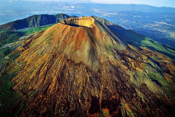
In 1631, there was an eruption that claimed the lives of 4,000 people. It turned out to be weaker than in 79, but the slopes of Vesuvius have since been inhabited by more people, which led to such casualties. After this event, the volcano became lower by 168 m. The eruption of 1805 destroyed almost all of Naples and claimed the lives of 26 thousand people.
The last time Vesuvius erupted lava flows was in 1944, leveling the cities of San Sebastiano and Massa. The number of victims was 27 people. After this, the volcano subsided. To monitor his activities, a volcanological observatory was built here.
Etna, Italy
Etna is the highest volcano in Europe. It is located in the northern hemisphere in the east of Sicily. Its height changes after each eruption, now it is 3429 m above sea level.

Etna has, according to various estimates, 200-400 side craters. Every 3 months an eruption occurs from one of them. Quite often this leads to the destruction of villages located nearby.
Despite the dangers, Sicilians densely populate the slopes of Etna. A national park was even created here.

Popocatepetl, Mexico
The second highest peak in Mexico, its name means “smoking hill.” It is located 70 km from Mexico City. The height of the mountain is 5500 meters.

Over 500 years, Popocatepetl erupted lava over 15 times, the last time this happened in 2015.
Klyuchevskaya Sopka, Russia
This is the highest peak of Kamchatka. Its height varies between 4750-4850 m above sea level. The slopes are covered with side craters, of which there are more than 80.

Klyuchevskaya Sopka reminds itself every 3 years, each of its activities lasts several months and is sometimes accompanied by ashfalls. The most active year was 2016, when the volcano exploded 55 times.
The most destructive disaster was in 1938, when the activity of Klyuchevskaya Sopka lasted 13 months.
Mauna Loa, Hawaii, USA
Mauna Loa can be found in the central part of the island of Hawaii. It rises 4169 m above sea level. Mauna Loa is of the Hawaiian type.

His characteristic feature- outpourings of lava that occur without explosions or ash emissions. Lava erupts through the central vent, cracks and fractures.
Cotopaxi, Ecuador
Cotopaxi belongs to the Andes mountain system. This is the second highest peak, rising to 5911 m.

The first eruption was recorded in 1534. The eruption had its most devastating consequences in 1768. Then the release of lava and sulfur was accompanied by an earthquake. The disaster destroyed the city of Latacunga and its surroundings. The eruption was so strong that traces of it were found in the Amazon basin.
Iceland
There are about three dozen volcanoes on the island of Iceland. Among them, some have long been extinct, but there are also active ones.

This island is the only one in the world where so many geological formations are located. Icelandic territory is a real volcanic plateau.
Extinct and dormant volcanoes
Volcanoes that have lost activity are either extinct or dormant. They are safe to visit, which is why these sites are more popular among travelers. On the map, such geological formations are marked with black stars, in contrast to active ones, marked with red stars.

What is the difference between an extinct and dormant volcano? Extinct species have not been active for at least 1 million years. Presumably, their magma has already cooled and will not explode. True, volcanologists do not exclude the possibility that a new volcano may form in their place.
Aconcagua, Argentina
Aconcagua is the highest peak in the Andes. It rises to 6960.8 m. The mountain was formed at the junction of the Nazca and South American lithospheric plates. Today the slopes of the mountain are covered with glaciers.

Aconcagua is of interest to climbers as the highest peak in South America, as well as the highest extinct volcano.
Kilimanjaro, Africa
If someone is asked to name the highest mountain in Africa, then he will name the most famous mountain on the African continent. It consists of 3 peaks, the highest of which is Kibo (5,891.8 m).

Kilimanjaro is considered dormant, with only gases and sulfur escaping from its crater. It is expected to become active when the mountain collapses, leading to a large-scale eruption. Scientists consider the peak of Kibo to be the most formidable.
Yellowstone, USA
Yellowstone is located on the territory of the same name national park. The peak belongs to supervolcanoes, of which there are 20 on Earth. Yellowstone is extremely dangerous because it erupts with incredible force and can affect the climate of the planet.

Yellowstone has erupted three times. The last eruption took place 640 thousand years ago, at which time the caldera depression was formed.
At this volcano, lava accumulates in a special reservoir, where it melts the surrounding rocks, becoming thicker. This reservoir is very close to the surface, which worries volcanologists.

The eruption is stopped by flows of water that cool the magma bubble and break out in the form of geysers. Since there is still a lot of energy left inside the bubble, it is expected to burst out in the near future.

The US authorities are taking all measures to prevent the eruption of Yellowstone, because it could claim the lives of 87 thousand people. One of the projects is the installation of a geothermal station, but this will require drilling wells, which could provoke a disaster not only in the country, but also on the entire planet.
Elbrus, Russia
The Caucasian peak today is attractive to climbers. Its height is 5621 m. It is a dormant formation in which volcanic processes occur. The last eruption supposedly took place 1.7 thousand years ago; 500 years ago it released a column of ash.

The activity of Elbrus is evidenced by geothermal springs located nearby. Scientists disagree on when to expect the next eruption, but what is certain is that it will lead to a mudslide.
Big and Small Ararat, Türkiye
Greater Ararat (5165 m) is located on the Armenian Highlands, 11 km from it is Little Ararat (3927 m).

The eruptions of Greater Ararat have always been accompanied by destruction. The last tragedy occurred in 1840 and was accompanied by a strong earthquake. Then 10,000 people died.
Kazbek, Georgia
Kazbek is located in Georgia. Locals They call it Mkinvartsveri, which translates as “ice mountain.” The height of the giant is 5033.8 m.

Kazbek is not active today, but is classified as potentially dangerous. It last erupted in 650 BC.
The mountain has very steep slopes, and mudslides are possible.
Conclusion
Volcanoes are among the most attractive tourist sites. Today they are no longer so dangerous, since their activity can be predicted by volcanologists. Research is underway to harness the energy of geological formations for the benefit of humanity.
When trying to go to the top of a volcano, especially an active one, it is necessary to collect information about its condition and listen to the forecasts of seismologists, since tragic incidents among tourists occur frequently.
We bring to your attention interesting video about active volcanoes of the world: